Yogyakarta Earthquake, Indonesia, 2006
Enlarge text Shrink text-
 Topic
Topic


- Work cat.: 2007040289: Yogyakarta earthquake of May 27, 2006:data view (On May 27, 2006 a major earthquake occurred near Yogyakarta Indonesia -- the largest in 60 years! 5,700 people died, 37,000 were injured, 300,000 buildings were damaged or destroyed; there was 3.1 billion dollars of economic losses)
- Wikipedia, the free encyclopedia, via WWW, Oct. 3, 2007(May 2006 Java earthquake, occurred at 05:54 local time on 27 May 2006 (22:54 GMT 26 May), in the Indian Ocean around 25 km (15 miles) south-southwest of the Indonesian city of Yogyakarta, near Galur, on the southern side of the island of Java (8.007° S 110.286° E), 17.1 km below the seabed, according to the U.S. Geological Survey; Jakarta's Meteorology and Geophysics Agency determined the hypocentre to be about 37 km south of Yogyakarta, 33 km below the seabed. The earthquake had a magnitude of 6.3. [1] Two aftershocks, measured at 4.8 and 4.6, occurred between 4 and 6 hours later)
- USGS home page, via WWW, Oct. 3, 2007(A strong earthquake occurred in Java, Indonesia about 25 km (15 miles) SSW of Yogyakarta or about 440 km (275 miles) ESE of Jakarta at 4:54 PM MDT, May 26, 2006 (May 27 at 5:54 AM local time in Java, Indonesia). Magnitude: 6.3; Location: 7.962°S, 110.458°E)


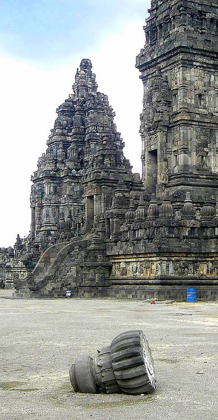


The 2006 Yogyakarta earthquake (also known as the Bantul earthquake) occurred at 05:53 local time on 27 May with a moment magnitude of 6.4 and a maximum MSK intensity of VIII (Damaging) in the Yogyakarta region of Java, Indonesia. Several factors led to a disproportionate amount of damage and number of casualties for the size of the shock, with more than 5,700 dead, tens of thousands injured, and financial losses of Rp 29.1 trillion ($3.1 billion). With limited effects to public infrastructure and lifelines, housing and private businesses bore the majority of damage (the 9th-century Prambanan Hindu temple compound was also affected), and the United States' National Geophysical Data Center classified the total damage from the event as extreme. Although Indonesia experiences very large thrust earthquakes offshore at the Sunda Trench, this was a large strike-slip event that occurred on the southern coast of Java near the city of Yogyakarta. Mount Merapi lies nearby, and during its many previous historical eruptions, large volume lahars and volcanic debris flowed down its slopes where settlements were later built. This unconsolidated material from the stratovolcano amplified the intensity of the shaking and created the conditions for soil liquefaction to occur. Inadequate construction techniques and poor quality materials contributed to major failures with unreinforced masonry buildings (then the most prevalent type of home construction), though other styles fared better.
Read more on Wikipedia >