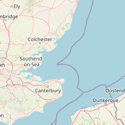
Great Wakering (England)
Enlarge text Shrink text-
 Place
Place
|
מספר מערכת
987007555356905171

Information for Authority record
Name (Latin)
Great Wakering (England)
Other forms of name
nne Great Wakering (Essex)
Coordinates
0.8165 0.8165 51.5516 51.5516 (gooearth )
E0004814 E0004814 N0513309 N0513309 (geonames )
Associated country
Great Britain
MARC

MARC
Sources of Information
- Forward Publicity Ltd. Rochford District official street plan, 1983?:map cover (Great Wakering)
- Muni. yr. bk., 1984(Great Wakering, parish, in Rochford Dist., Essex)
- Barth. gaz. of places in Brit., 1986(Great Wakering, Essex, vil.; no others cited)

Wikipedia description:
Great Wakering is a village in the Rochford District in Essex, England. It is approximately four miles east of Southend. Great Wakering consists mainly of two roads: the High Street, which runs from the junction of Star Lane, and New Road, which begins outside St Nicholas' Parish Church and runs down to the bridges for Foulness Island.
Read more on Wikipedia >