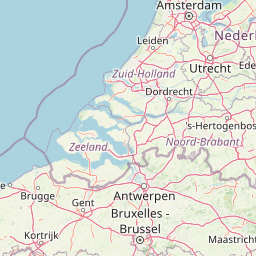
Oudenhoorn (Netherlands)
Enlarge text Shrink text-
 Place
Place
|
מספר מערכת
987007562538405171

Information for Authority record
Name (Latin)
Oudenhoorn (Netherlands)
Coordinates
4.1917 4.1917 51.8269 51.8269 (gooearth )
Associated country
Netherlands
MARC

MARC
Sources of Information
- Uitgeverij en Reclame-Adviesbureau Rijnland. Plattegrond van Gemeente Bernisse, Abbenbroek ... 1988?:map recto (Oudenhoorn)
- BGN gaz. Neth., 2nd ed., 1982(Oudenhoorn, PPL, 51p0s50ʹN 4p0s12ʹE, Zuid-Holland)

Wikipedia description:
Oudenhoorn is a village in the Dutch province of South Holland. It is part of the municipality of Voorne aan Zee and lies about 3 km east of Hellevoetsluis. The village was first mentioned in 1356 as "den Hoorn". The current name means "old corner (of a dike)". The eponymous polder was created in 1356 by order of Machteld van Voorne. Oud (old) has been added to distinguish from Nieuwenhoorn. Oudenhoorn was an independent municipality until 1980 when it was merged into Bernisse. In 2015, it became part of Hellevoetsluis.
Read more on Wikipedia >