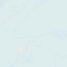
Byrd Glacier (Antarctica)
Enlarge text Shrink text-
 Place
Place
|
מספר מערכת
987007563909105171

Information for Authority record
Name (Hebrew)
קרחון בירד (אנטארקטיקה)
Name (Latin)
Byrd Glacier (Antarctica)
Coordinates
159 159 -80.3333 -80.3333 (gooearth )
See Also From tracing topical name
Glaciers Antarctica
MARC

MARC
Other Identifiers
Wikidata:
Q764134
Library of congress:
sh2004007735
Sources of Information
- Work cat.: Byrd Névé (Antarctica), 2003.
- GNIS Antarctica, Apr. 7, 2004(Byrd Glacier, glacier, 80⁰15ʹS, 160⁰20ʹE; A major glacier, about 85 mi. long and 15 mi. wide, draining an extensive area of the polar plateau and flowing eastward between the Britannia Range and Churchill Mountains to discharge into Ross Ice Shelf at Barne Inlet.)
- Columbia Gazetteer of the World, 1998:p. 483 (Byrd Glacier; large glacier in E Antarctica that flows from the polar plateau bet. the Britannia Range and the Churchill Mts. into the Ross Ice Shelf at Barne Inlet 85mi/140 km long, up to 25 mi/40 km wide; 80⁰15ʹS, 160⁰20ʹE; Byrdbreen Glacier 71⁰45ʹS, 026⁰00ʹE, is not the same Glacier though inconsistently Byrd Glacier is listed as a Variant name of Byrdbreen)
- Times Atlas of the World, 1999:plate 121 (Map shows Byrd Glacier)

Wikipedia description:
The Byrd Glacier (80°20′S 159°00′E) is a major glacier in Antarctica, about 136 km (85 mi) long and 24 km (15 mi) wide. It drains an extensive area of the Antarctic plateau, and flows eastward to discharge into the Ross Ice Shelf.
Read more on Wikipedia >